GWO is the only company utilizing ClimatePulse Technology for Tracking Historical landfall Hot-Spots into the Future
knowing how many United States landfalls will occur and where is the reason Global Weather Oscillations is the foremost organization in seasonal hurricane predictions”
TAMPA / OCALA , FL, UNITED STATES, February 23, 2025 /EINPresswire.com/ -- The last nine Hurricane Seasons from 2016 through 2024 have been extremely active with an average of 19 named storms occurring each season as compared to the long-term average of only 12 to 13 named storms. In addition, the United States experienced an average of 3 hurricane landfalls each year since 2016 – the long-term average is only 1 hurricane landfall.— Professor David Dilley
The hyperactive hurricane seasons have caused extreme damage – fresh in our memory is Major Hurricane Heline that struck the Eastern Panhandle of Florida last year and caused historical flooding in North Carolina. Then came Major Category 3 Hurricane Milton that made landfall in southwest Florida and caused extreme damage across the central portion of the state.
Will the hyperactive and very dangerous seasons of the past 9-years carry over to this year (2025), and what is causing this extreme activity?
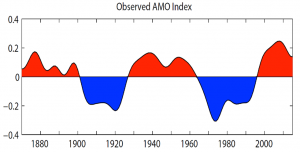
The ocean water temperatures have been running much warmer than normal across the Gulf of American, Caribbean and Atlantic since 2016, and this has added fuel for developing storms. Professor David Dilley of Global Weather Oscillations (GWO) predicts that this trend will continue during the 2025 hurricane season due to the naturally occurring Atlantic Multi-decadal Oscillation (AMO). The AMO is a naturally occurring warm ocean water cycle that recurs about every 70 years (there have been 3 AMO cycles since 1875). The Atlantic Ocean Basin (which includes the Caribbean and Gulf of America) - entered the warmest portion of the current AMO Cycle in 2016, and this is why there have been so many hurricanes.
During the current AMO warm ocean cycle, the United States has experienced landfalls by 40 named storms since 2016, with 25 of them being hurricanes - 11 of which were major hurricane landfalls. This very active hurricane cycle will continue for several more years.
2025 Prediction and What to Expect!
An average hurricane season has 12-13 named storms, 6 hurricanes and 1 United States hurricane landfall. The combination of the AMO warm ocean water cycle, favorable atmospheric conditions, and the enhanced ClimatePulse Cycle – will provide favorable conditions for another active and likely destructive hurricane season in 2025.
Last year (2024) Professor David Dilley predicted 20 named storms, and the season ended with 18 named. Of most importance, 4 to 5 United States hurricane landfalls were predicted – and 5 occurred within the hot-spot predicted areas.
Professor Dilley’s Outlook for 2025 is for 16 named storms (3 to 4 above average), 7 hurricanes with 2+ United States Landfalls, but stresses that due to the continuance of warmer than normal ocean waters – one or two 2 tropical storms could feed on the warm water and intensify into additional hurricane landfalls. Professor Dilley also stresses – “You should not simply focus on the predicted number of Atlantic Basin named storms. What is much more important is - knowing how many United States landfalls there will be – and where they will occur”. The ability to predict landfall locations in advance is the reason Global Weather Oscillations is the foremost organization when it comes to seasonal hurricane predictions.
GWO has 13 prediction zones that detail what to expect within that zone – or the entire package of all 13 zones that detail expected landfall hot-spots for hurricanes and/or tropical storms. The prediction zones are available at www.GlobalWeatherCycles.com or www.GlobalWeatherOscillations.com.
Global Weather Oscillations (GWO) utilizes ClimatePulse Technology that tracks historical hurricanes through time and into the future. GWO is the only company utilizing this technology for predicting where the landfall Hot-Spots will occur months in advance. The predictions prepared by Professor David Dilley - pinpoint landfall Hot-Spots on a seasonal basis with an accuracy near 87%., and the predictions are split into 13 United States and Lesser Antilles zones. Detailed predictions are available via www.GlobalWeatherCycles.com or www.GlobalWeatherOscillations.com.
GWO and Professor Dilley invite you to join our (free) preseason Outlook Webinars during March into May. During the hurricane season, GWO and Professor David Dilley conduct weekly hurricane outlook webinars for clients. The webinars look 2 weeks into the future and begin additional tracking webinars if a tropical system is likely to form and are expected to have landfall. The tracking webinars are typically initiated 8 to 15 days prior to the landfall.
Professor David Dilley
Global Weather Oscillations
+1 352-789-4461
email us here
Legal Disclaimer:
EIN Presswire provides this news content "as is" without warranty of any kind. We do not accept any responsibility or liability for the accuracy, content, images, videos, licenses, completeness, legality, or reliability of the information contained in this article. If you have any complaints or copyright issues related to this article, kindly contact the author above.


