
WHITE ROCK, BC / ACCESSWIRE / May 19, 2021 / TDG Gold Corp (TSXV:TDG) (the "Company" or "TDG") is pleased to provide an update of the review of the historical exploration work and 2021 plans for its former producing high-grade gold-silver Mets mining lease.
TDG's former producing, high-grade gold-silver Baker, Shasta and Mets mines are located within the 60 kilometres ("km") road-linked, historical "Toodoggone Production Corridor" (see Figure 1), which is now actively being re-explored by TDG and other exploration companies for lower grade, bulk tonnage mineralization. The corridor runs from Centerra Gold's former producing Kemess mine in the southeast to Thesis Gold's Ranch project in the northwest and also includes Benchmark Metal's Lawyers project which recently published an initial mineral resource estimate.
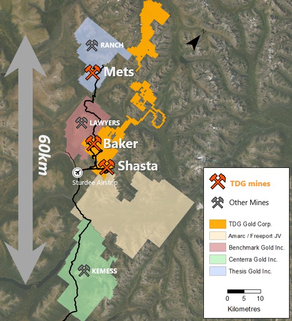
Figure 1 shows the road-connected "Toodoggone Production Corridor" which includes TDG's former producing high-grade gold-silver Baker, Shasta and Mets mines. Baker acts as the "gateway" to the northwestern section of the corridor.
The Mets mining lease covers 200 hectares and is road accessible from Baker via Benchmark Metals' Lawyers project. Mets was discovered and systematically explored between 1980-1992 including a reported 8,784 metres ("m") of diamond drilling (of which TDG has recompiled 7,944 m), 2,622 m of trenching and 350 m of underground development on one level. Historical drill highlights include 9.52 grams per tonne ("g/t") gold ("Au") and 1.9 g/t silver ("Ag") over 25.90 m and 3.57 g/t Au and 2.36 g/t Ag over 46.40 m, including 13.93 g/t Au and 2.00 g/t Ag over 11.80 m.
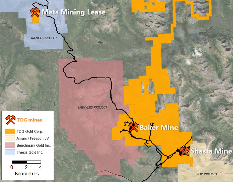
Figure 2: Mets location map.
According to a Skeena Resources Limited ("Skeena") news release of February 05, 2009 about Mets: "...the main area of interest consists of a tabular core of silicified rock and quartz barite veining in three separate but genetically related zones; the A zone (and its extension), the Footwall zone, and the 400 South zone."
The same news release went on to note: "...two previous operators calculated a gold resource. These historic tonnages are quoted here for context only, as the calculations are not compliant with current Canadian Securities 43-101 reporting guidelines and will require both verification and updating. The A zone has a strike length of 140 metres, a true thickness of 6 to 10 metres and vertical extent of up to 75 metres. Measured geological resource for the A zone is 143,321 tonnes grading 11.31 grams per tonne gold (Assessment Report 16692, source BC Minfile)"1. The Skeena news release goes on to state, "Inferred resource for the less tested combined Footwall and N75 zones are 317,485 tonnes grading 11.31 g/t Au", although the original document that this was referenced from is not available for confirmation and so the statement should be regarded with caution.
In 2021, TDG intends to undertake exploration activities to define the surface extensions of the mineralized gossans to the north of the N75 fault (see Figure 3), complete metallurgical testing of samples recovered from stockpiles and to start environmental baselines studies. This will help determine the value of Mets as a potential source of higher-grade ore to blend with lower grade ore at TDG's former producing gold-silver Shasta mine.
Mets Geology
Historical mapping of the property has demonstrated gold and silver mineralization hosted within brecciated quartz and quartz-barite veins running in a north-south orientation for 1.2 km through Jurassic Hazelton Volcanic rocks. There are two primary target areas, the southerly "A-Zone" and the northern gossans, which are divided and offset by the northeast to southwest trending "N75 Fault."
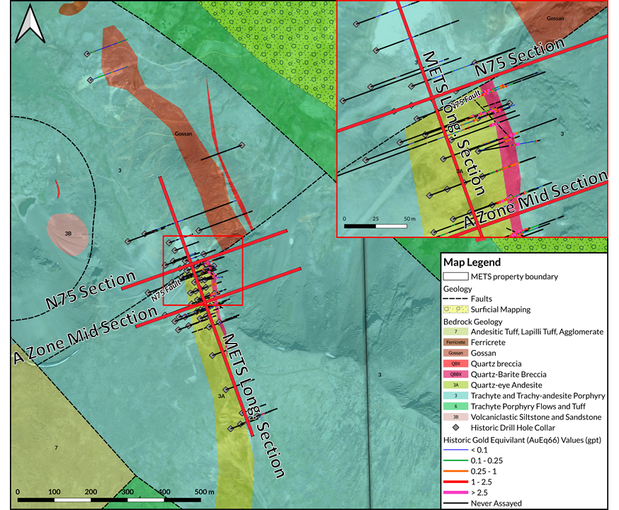
Figure 3: Mets geology map and historical drilling.
Compilation of historical data has found a total of 64 drill holes at Mets, with 45 focusing on the A-Zone. The total meterage drilled in these holes was 7,944 m, with 29% of the core having assay results. The northern gossans remain largely untested with early drilling missing the offset along the N75 fault.
The A-Zone ore body plunges north-northeast at an angle of 40 degrees, with mineralization generally between 15 m and 40 m, with true widths of 25 m (although this needs new drill testing to confirm).
Mets Long Section
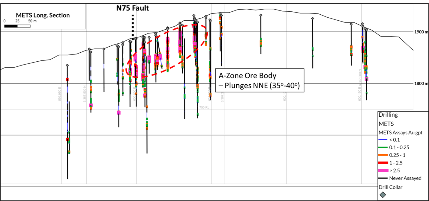
Figure 4: Mets long section illustrating plunge of A-Zone ore body.
Mets Cross Sections
Table 1 shows select historical drill assay results from drilling at the north of the A-Zone (adjacent to the N75 Fault) and in the centre of the A-Zone. The section shows that continuation of the mineralization down-dip and which remains open at depth.
Table 1: Select historical drill assays from Mets.
| Hole ID | From (m) | To (m) | Composite Length (m) | Au (g/t) | Ag (g/t) |
| MT86-08 | 21.95 | 47.85 | 25.90 | 9.52 | 1.92 |
| including | 21.95 | 39.47 | 17.52 | 13.67 | 1.28 |
| including | 40.23 | 44.81 | 4.58 | 1.31 | 1.35 |
| | | | | | |
| MT86-12 | 57.45 | 84.43 | 26.98 | 2.30 | 2.22 |
| including | 57.45 | 69.65 | 12.20 | 4.69 | 0.74 |
| including | 78.79 | 81.08 | 2.29 | 0.28 | 15.59 |
| | | | | | |
| MT87-23 | 22.90 | 53.90 | 31.00 | 2.27 | 2.50 |
| including | 35.80 | 39.80 | 4.00 | 14.46 | 2.08 |
| | | | | | |
| MT87-48 | 59.70 | 127.10 | 67.40 | 2.18 | 3.52 |
| | | | | | |
| MT87-49 | 41.20 | 53.70 | 12.50 | 2.50 | 5.31 |
| | | | | | |
| MT87-55 | 53.30 | 99.70 <
© 2024 PR WIRE INDIA - A Digital Product of DoonITrix Pvt Ltd
|